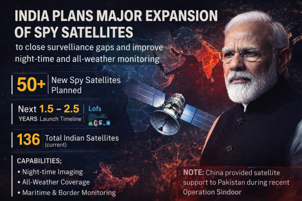
India is preparing for a major leap in space-based intelligence as the government moves to launch more than 50 new surveillance satellites (Spy) equipped with advanced night-time and all-weather imaging capabilities. The ambitious plan is aimed at strengthening national security, improving border monitoring, and closing intelligence gaps that reportedly surfaced during Operation Sindoor.
The move has gained urgency amid reports that China provided satellite and intelligence support to Pakistan during the operation, raising serious concerns within India’s security establishment about real-time surveillance disadvantages.
Why India Is Rushing This Expansion
Operation Sindoor acted as a wake-up call for Indian defence planners. While India possesses capable space assets, officials believe the operation highlighted limitations in continuous monitoring, particularly during night hours and adverse weather conditions.
In modern conflicts, satellite intelligence plays a decisive role. Continuous imagery, rapid data processing, and real-time situational awareness can determine outcomes on the ground. The reported external satellite support to Pakistan reinforced the need for India to rely more heavily on its own dedicated and persistent surveillance network.
What the Plan Includes
The upcoming expansion is expected to add more than 50 dedicated surveillance satellites over the next two to three years. These satellites will significantly increase India’s ability to monitor borders, coastlines, and strategic zones with shorter revisit times.
India currently operates a mix of earth observation, communication, and navigation satellites, but the new focus is on strengthening military and intelligence-specific assets. The expansion will sharply increase the number of satellites capable of real-time monitoring for defence agencies.
Night-Time and All-Weather Imaging Explained
A key feature of the new satellites will be advanced night-time and all-weather imaging systems. These include Synthetic Aperture Radar technology, which can capture images regardless of darkness, cloud cover, or smoke.
Unlike traditional optical satellites that depend on sunlight, radar-based satellites can detect troop movements, vehicles, infrastructure changes, and maritime activity around the clock. Low-light and infrared imaging will further improve clarity during night operations.
This capability is critical in regions with frequent cloud cover, during monsoons, and in high-altitude or forested terrain where visibility is limited.
How This Will Help India
The expanded satellite network will provide several strategic advantages.
First, it will allow round-the-clock monitoring of borders and sensitive regions, reducing the risk of surprise movements or build-ups.
Second, it will strengthen maritime surveillance, helping track suspicious vessels, illegal fishing, and shipping movements across the Indian Ocean region.
Third, it will reduce India’s dependence on commercial satellite imagery and external data sources during crises.
Fourth, the system will support disaster management by enabling faster damage assessment during floods, cyclones, and earthquakes.
Finally, it will boost India’s domestic space industry by creating demand for satellite manufacturing, launch services, data analytics, and artificial intelligence based image processing.
How Other Countries Compare
Globally, space-based surveillance has become a cornerstone of military power.
The United States operates the world’s largest and most sophisticated military satellite network, combining optical, radar, and signal intelligence systems with commercial partnerships.
China has rapidly expanded its satellite fleet, deploying hundreds of military and dual-use satellites that provide high revisit rates and regional dominance in surveillance.
Russia maintains a mix of heavy strategic satellites and tactical reconnaissance systems, while countries like Israel, France, and Japan operate smaller but highly advanced constellations focused on precision and reliability.
India’s new plan aims to bridge the gap between major space powers and emerging regional players by building a strong, sovereign surveillance capability.
Challenges Ahead
While the plan is ambitious, it comes with challenges.
Deploying dozens of satellites requires sustained funding, strict project management, and coordination between space, defence, and intelligence agencies.
Equally important is the ground infrastructure needed to process massive volumes of data quickly. Without advanced analytics and secure networks, satellite images cannot be converted into timely intelligence.
There are also concerns about space congestion and debris as satellite numbers increase, requiring improved space traffic management.

The Bigger Picture
India’s decision to rapidly expand its spy satellite network marks a strategic shift. It reflects an understanding that future conflicts will be fought as much in space and data networks as on land, sea, and air.
Operation Sindoor exposed the cost of surveillance gaps in a region where adversaries are increasingly networked and technologically supported. By strengthening its eyes in the sky, India aims to ensure that intelligence disadvantages do not shape future security outcomes.
If executed effectively, this satellite push could redefine India’s strategic posture, offering greater autonomy, faster decision-making, and stronger deterrence in an increasingly contested region.